Home
Chinese (Simplified) French German Greek Portuguese Russian Spanish
  • Home
  • Things to Do
    • ALL Things to Do
    • Attractions
    • Family Fun
    • Tour Services
    • Shopping
    • Museums
    • Night Life
    • Recreation
    • Weddings
    • Golfing
    • Transportation
    • Events Calendar
    • LIVE MUSIC
    • ALL Categories
  • Places to Stay
    • ALL Places to Stay
    • Bed and Breakfasts
    • Condos and Resorts
    • Hotels / Motels
    • Pet Friendly
    • Vacation Rentals
    • Waterfront
    • Camping
  • Eat & Drink
    • ALL Restaurants
    • Bars and Pubs
    • Breakfast
    • Family Fare
    • Fine Dining
    • Food Trucks
    • Happy Hour
    • Seafood
    • Spanish
    • ALL Categories
  • Events
    • ALL Events
    • Featured Events
    • Festivals
    • LIVE MUSIC
    • Live Entertainment
    • Arts & Culture
    • Sports & Outdoors
    • For Kids
    • Seasonal Events
    • Local Things to Do
    • Food Events
  • Regions
    • Historic Downtown
    • Anastasia Island
    • Lincolnville
    • North City
    • Ponce de Leon Blvd
    • Ponte Vedra
    • Ponte Vedra Beach
    • South St. Augustine
    • SR-16 to I-95
    • St. Augustine Beach
    • Uptown
    • US1 North
    • Vilano Beach
    • West St. Augustine
    • World Golf Village
    • ALL Regions
  • Map
Chinese (Simplified) French German Greek Portuguese Russian Spanish

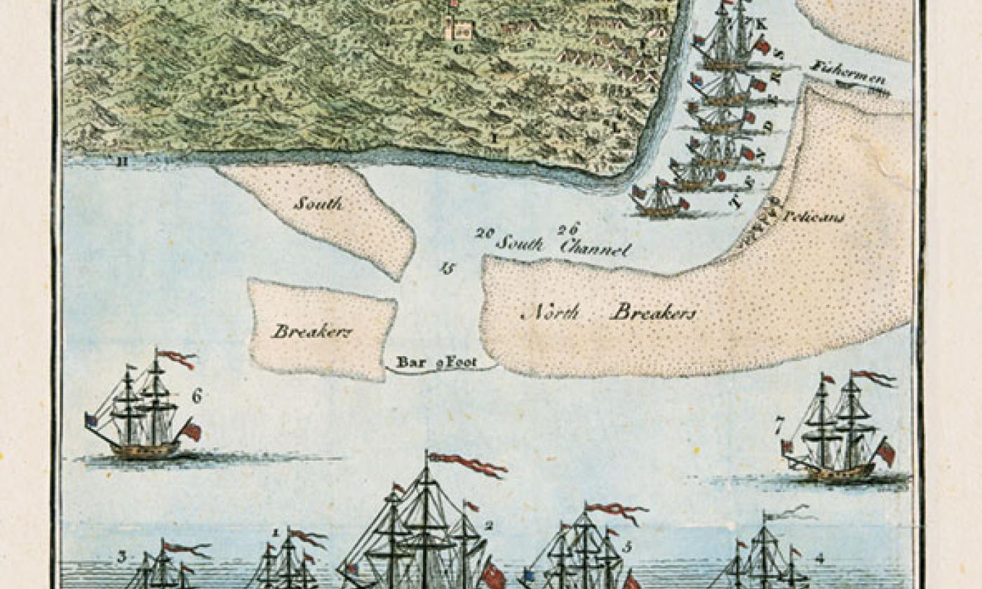
St. Augustine, Showing Georgian Attack, 1740, Silver

View of St. Augustine, Silver 1740

  • "A View of the Town and Castle of St. Augustine and the English Camp before it. June 20, 1740 by Thomas Silver. London July 1740, Colored. 11.5 X6.5. This beautifully engraved Msp/View & text was drawn on the spot by an English Naval Officer in the Sloop Hector in May 1740, after which it was sent back to London to be published in The Gentleman's Magazine, a monthly magazine of current affairs in the July 1740 issue. The map depicts the famous Siege of St. Augustine by General Oglethorpe who approached the area both from the land & the sea. The map & view was also published later in 1742 in "Oglethorpe. An Impartial Account of the late Expedition Against St. Augustine under General Oglethorpe. by J. Huggonson. The View shows finely engraved drawings of the ships, with buildings along the shore & the Castle, with channels & breakers at the harbor entrance. Below the View are detailed notes & a key outlining the events of the encounter & the subsequent raising of the Siege.

Share this:
Visit Bayfront Westcott House
Visitors Info
Got a Question?
Things to Do
  • ALL Things to Do
  • Attractions
  • Tour Services
  • Shopping
  • Night Life
  • Recreation
  • Weddings
  • Attractions Association
Places to Stay
  • ALL Places to Stay
  • Bed & Breakfasts
  • Condos & Resorts
  • Hotels & Motels
  • Vacation Rentals
  • Waterfront
  • Pet Friendly
Eat & Drink
  • ALL Restaurants
  • Seafood
  • Family Fare
  • Bar / Lounge / Pub
  • Breakfast
  • Fine Dining
  • ALL Categories
Events
  • ALL Events
  • Featured Events
  • Festivals
  • Live Music
  • Live Entertainment
  • Arts & Culture
  • Sports & Outdoors
  • For Kids
History
  • Historical Books
  • Old Maps & Photos
  • Old Fort - 3D Tour
  • Written History
  • Written Timeline
  • Black History
About Us
  • Advertise with Us
  • List your Business
  • Contact Us
  • Submit an Event
  • Media Resources
  • Corrections?
  • Map & Guide

Follow Us!